

It was raining heavily the night before our climb. At the back of my mind I wondered what our plans would be if there's a typhoon - should we going back to Iloilo City and spend the rest of the day visiting churches and museums? Thankfully, however, the rain subsided by morning. With a slight drizzle above our heads, we started hiking at around 6AM, wadding across muddy rice fields. Our guides assured us that the mountain slopes will not be as muddy.
Luckily, and indeed, we eventually reached the mountain's rocky portion where even my rubber sandals provided a good grip. The soil looks as though someone sprinkled crushed granite all over it. About a quarter of the train consists of irrigation aqueducts, which ends on a huge river. I couldn't count the gullies, rivers and small falls we encountered. We reached the last water source after two hours; from there the trail became steeper. The "assaults" continued as we exited the forest and reached the mountain's grassy portion were locals graze their cattle.
 |
| With travel buddy Ron. This river is where the irrigation aqueducts end. |
 |
| The flooded trail. |
Here the majestic mountain range on which Napulak is part of comes into fuller view. From afar, the rice terraces in Brgy. Bagay are also visible. Higher still, however, it seemed that the summit is still covered with clouds. Our guides said that a greater portion of Antique, Iloilo and even Guimaras are visible on good weather.


 |
| Mt. Napulak is part of an extensive mountain range. |
 | ||
This is how you get to the nipple top - a makeshift ladder made of branches.
|

 |
| At the very peak. |
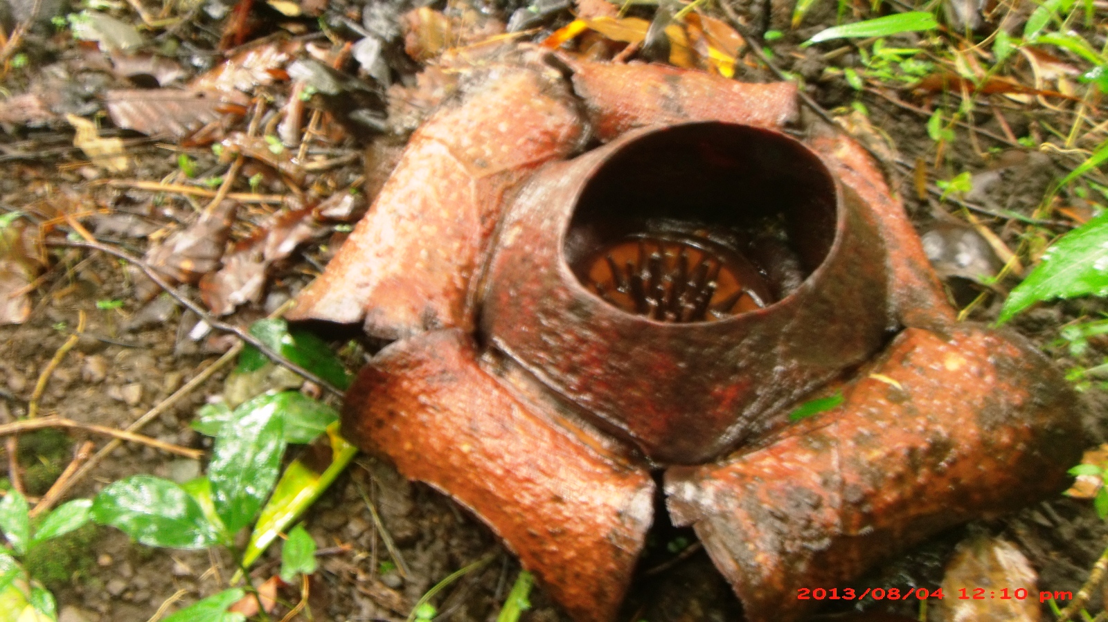 |
| Behold, the Rafflesia |
Here are some of the flora and fauna we found along the trail. There are also wild berries near the summit; I was so eager to eat them that I forgot to take a picture.


Climb Details
There are vans at Iloilo International airport going to SM City (P40, 1 hr). From the transport terminal in SM City, you can take a jeep with signboard "Super" (public "supermarket") (P7.50, 10 min). You can opt to buy provisions at the nearby Robinson's. At Super, we took a jeep for Igbaras (P40, 1.5 hrs) where we met the tourism officer and registered. All climbs to Napulak are arranged by the Tourism Office, who coordinates with Brgy. Bagay for your guides, transportation and other needs. It is recommended that you contact them at least two days before the climb. From Igbaras, we took a single motorcycle to Brgy. Bagay (P100, 1 hr). At Brgy. Bagay, we met Kap Evelyn and registered. Hikers who will spend the night at Bagay are usually offered whatever available space is at the Barangay Hall (usually the clinic), but we insisted on staying at Kap's own house. Kap arranged two guides for us (P600/2 guides).
Mt. Napulak may be dayhiked, taking 3 hours for both ascent and descent. Hikers who intend to catch the 5 PM last trip back to Iloilo should hike as early as possible, and reach the summit before noon. For overnighters, tents, rain gear and thermals are a must as it can get extremely cold close to summit, where the campsite is also located. You can opt to take the same trail from Brgy. Bagay, or traverse from Brgy. Bagay to Brgy. Tignaba.
There are no blood leeches (limatiks) along the trail. The incline is low to moderate and suitable for beginners, with the steepest portion onlybeing the one after the last water source. One liter of water will suffice before you reach the first water source. Note that the last water source is an hour away from the summit. You may need to bring additional containers if you opt to stay overnight.
Contacts to Igbaras are available at their website.
Sidetrip to Guimaras
Oh, I forgot to mention that we headed first to Guisi, Guimaras before going to Igbaras. Here's how to get there: From the transport terminal in SM City, take a jeep to City Proper (P7.50, 15 min) and tell the driver to drop you off at Ortiz Warf. From there, Guimaras is just a boat ride away (P12, 20 min). You can then take a jeep that passes to Dolores (P40, 1.5-2 hours), and tell the driver that you intend to go to Guisi Beach. You will then have to take single motorcycle (P50, 20 min) to Guisi Clearwater Resort. Entrance is P20/head, cottage P100/hour. Weather permitting, you can explore the area and look out for corals. There are other resorts in the area such the slightly more expensive Kenyama (entrance P50 for adults, P20 children).
 |
| Orange-ish sand, rocky sea floor, clear waters, some interesting rock formations. |


No comments:
Post a Comment